Researchers at Emory University’s Rollins School of Public Health are unveiling a major update to their HIV interactive online map, AIDSVu.
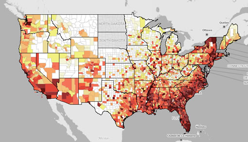
AIDSVu allows users to view HIV rates in the U.S. by state and county, alongside key social determinants of health - such as poverty, lack of health insurance and educational attainment. It also provides local information about HIV testing and treatment site locations, state AIDS Drug Assistance Programs and the estimated percentage of HIV diagnoses that are made late in the course of the disease.
With the new update, AIDSVu now shows the latest HIV prevalence data for 13 U.S. cities by ZIP code or census tract. Cities include: Atlanta, New York City, New Orleans, San Francisco and Detroit.
"The new city maps on AIDSVu help us understand which communities are most impacted by HIV and where we need to focus resources," says principal researcher Patrick Sullivan, PhD, DVM, associate professor of epidemiology, Emory University’s Rollins School of Public Health.
"The information on AIDSVu can help educate all Americans about what HIV looks like in the U.S., and support efforts to prevent new HIV infections, expand HIV testing and improve care for people living with HIV."
AIDSVu is updated regularly as new data and information become available.
To visit the AIDSVu site, please click here.